Description:
Save Big on Coursera Plus. 7,000+ courses at $160 off. Limited Time Only!
Grab it
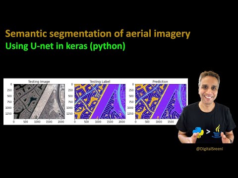
Learn to perform semantic segmentation on aerial satellite imagery using U-net in this comprehensive tutorial video. Explore the process of pre-processing aerial data, including RGB label conversion, to prepare it for U-net implementation. Follow along as the instructor demonstrates U-net training and prediction techniques. Download the code used in the video from the provided GitHub repository link. Utilize a dataset of Dubai aerial imagery, annotated with pixel-wise semantic segmentation in six classes. Master techniques for handling various image sizes, cropping to sizes divisible by 256, and extracting patches. Convert HEX color codes to RGB values, then to integer values, and finally to one-hot encoded format. Discover methods for converting predicted segmented images back to original RGB colors and merging predicted tiles into larger images with minimal blending artifacts. Cover topics including dataset exploration, image resizing, mask handling, dummy label creation, RGB to integer conversion, label printing, and model compilation.
Read more
Semantic Segmentation of Aerial Imagery Using U-Net
Add to list
#Computer Science
#Artificial Intelligence
#Computer Vision
#Semantic Segmentation
#Engineering
#GIS
#Remote Sensing