Description:
Explore a 21-minute video demonstrating the use of Landsat Earth Observation multispectral imagery and ProRaster Scientific to quantify vegetation health changes on Macquarie Island following a pest species eradication program. Learn how to acquire and process Landsat 7, 8, and 9 scenes from 1999-2002 and 2022-2024 to compare NDVI (vegetation index) statistics before and after the eradication efforts. Follow along as the presenter imports scenes, creates composited mosaic products, and performs various processing techniques including masking, spectral index calculation, and statistical analysis. Discover the stark improvement in vegetation health that testifies to the success of the eradication program on this remote island located between New Zealand and Antarctica. Gain insights into using geospatial tools for environmental monitoring and assessment of conservation efforts.
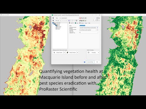
Quantifying Vegetation Health at Macquarie Island Before and After Pest Species Eradication
Add to list
#Engineering
#GIS
#Remote Sensing
#Computer Science
#Artificial Intelligence
#Computer Vision
#Image Processing
#ProRaster Scientific
#Landsat