Description:
Save Big on Coursera Plus. 7,000+ courses at $160 off. Limited Time Only!
Grab it
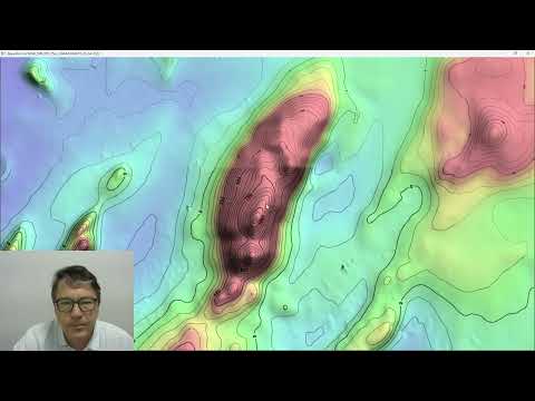
Watch a 33-minute technical tutorial exploring advanced contouring functionality in geospatial software, with detailed demonstrations of essential features including contour layer creation, opacity settings, masking, spacing adjustments, and line customization. Master techniques for implementing manual contours, managing dropouts, and adding labels while learning practical applications through examples like the Atlas Mountains. Progress through hands-on demonstrations of component controls, clipping operations, and visualization options that enhance topographic data representation. Gain comprehensive understanding of contouring tools through systematic coverage of core concepts and advanced features, enabling creation of precise topographic visualizations for scientific and engineering applications.
ProRaster Scientific 2.5.01 - Deep Dive into Contouring Features
Add to list
#Data Science
#Data Analysis
#Geospatial Analysis
#Science
#Earth Science
#Geography
#Cartography
#Geospatial Data
#Digital Elevation Models
#Raster Data