Description:
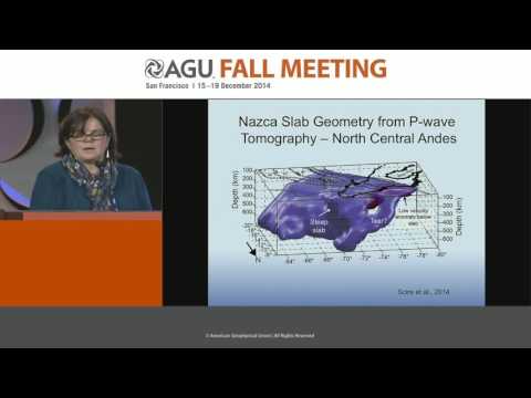
Explore a comprehensive lecture on the seismic imaging of the Central Andes and subducting Nazca Slab, presented at the 2014 AGU Fall Meeting. Delve into 20 years of portable seismology results, covering topics from the BANJO project in 1994 to the PULSE project in 2014. Examine teleseismic tomography techniques used to image the subduction zone, and investigate earthquake locations and slab folding. Gain insights into Pampean and Peru flat slab subduction, hydration and dehydration processes in the slab, and new slab contours. Study the depth to Moho in the North Central Andes and analyze the Altiplano Puna Volcanic Complex. Discover the potential formation of a batholith in the Central Andes and explore two causes of lithospheric removal. This 51-minute Gutenberg Lecture, presented by S. L. Beck from the University of Arizona, offers a deep dive into the evolving understanding of the complex geological structures in the Central Andes region.
New and Evolving Seismic Images of the Central Andes and Subducting Nazca Slab - 20 Years of Portable Seismology Results
Add to list